Backcountry Fly Fishing on the Rooftop of Wyoming
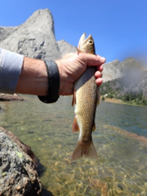
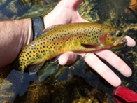
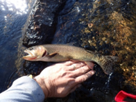
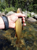
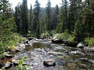
If you are looking for a remote western backcountry experience where the variety of the terrain and scenery is equally matched by the variety of fish you will catch then look no further than the Wind River Range of the Rocky Mountains in Wyoming. The WRR encompasses 2.25 million acres in an area roughly 110 miles long and 35-40 miles wide. The crest of the range forms the Continental Divide and three major western rivers are born on the 175+ glaciers still clinging to the peaks: the Gros Ventre River, which flows into the Snake River; the Green River, which is the largest fork of the Colorado; and the Wind River, which becomes the Bighorn and is the largest fork of the Yellowstone River. This is the land where the Shoshone Indians once lived and portions of the range are inside the Wind River Indian Reservation. The paths they pioneered back and forth over the mountains are incorporated into the over 700 miles of trails that can be utilized to access some of the most remote and beautiful areas in the lower 48.Historically most of the alpine lakes in this region were devoid of trout. Isolated in hanging valleys their outlet streams contained steep waterfalls that proved to be a barrier to upstream migration. The native cutthroats had managed to establish populations in only a handful of the lakes at the edge of the mountains. In 1929 Finis Mitchell established a fishing camp in the Big Sandy Openings and for the next seven years through the Great Depression he stocked hundreds of remote lakes with an estimated 2.5 million trout by horse packing in five gallon buckets full of fingerlings. Today we benefit from these efforts and others that followed including federal and state stockings programs. We are blessed with a wilderness area that is four times larger than the Smoky Mountains and contains over 1,000 lakes with miles of creeks connecting them. With cutthroat, rainbow, brook, golden, brown and lake trout to be found throughout the range the hardest decision might just be, “Where do I start?”In August my buddies and I completed a six day backpacking and fishing trip through the Winds. Our forty mile loop led us over a route with elevations ranging between 9,000 and 12,000 feet. We went through forests of lodgepole and whitebark pines, climbed into alpine meadows, and traversed through barren passes and plateaus where it was hard to even spot a tree below us. We crossed the Continental Divide in two separate places and walked past more than twenty lakes ranging from the size of a football field to over two miles long. Perhaps our greatest challenge was having to decide where not to fish because we simply did not have time to fish them all.Our trip started and ended at the trailhead at the Big Sandy Lodge. This is the site where Finis Mitchell had established his tent camp eighty-five years ago. We headed north along the Continental Divide Trail gradually gaining elevation to the open meadows of Fish Creek Park. We passed several lakes and creeks until arriving at Skull Lake to set up camp. Here we were surprised to find a group of rangers with the Wyoming Game and Fish Department. We were over 10 miles from the trailhead and these guys had carried in a raft and a system of nets to assist in fish population studies. It was great to see these men working to further improve the fishing in such a remote wilderness. Hungry brook trout sipped BWO duns and emergers nearly every cast we made into the lake as the evening sun set the crest of the Rockies on fire in the background.
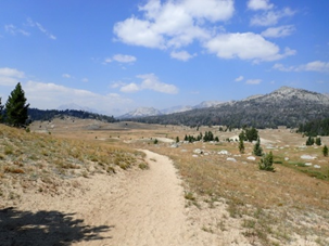
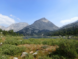
Views of distant mountains emerged as we arrived at Fish Creek Park
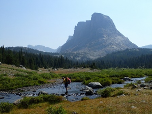
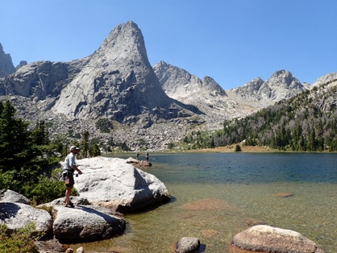
Mae’s Lake is guarded by the distinctive Pyramid Peak
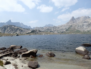
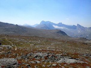
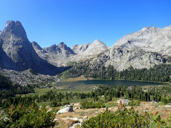
Alpine terrain surrounds Pyramid Lake
The next morning we continued on past Mae’s Lake to the desolate Pyramid Lake. This stunning fifty-five acre lake sits about a half-mile from the Continental Divide at 10,570 feet and is completely above tree line. At this point we had left the trail but a one mile cross country scramble brought us to the Continental Divide at 11,600 feet where we dropped down to reconnect with the trail at Hailey Pass. We had now left the waters that ultimately drained into the Colorado River and entered the Wind River drainage. It was hard to imagine that the snowfield just below our feet was destined to flow all the way to New Orleans via the Wind, Bighorn, Yellowstone, Missouri, and finally Mississippi River!
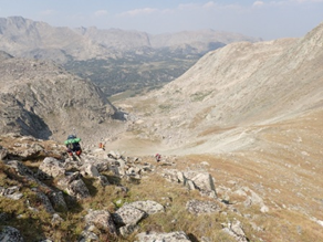
Descending from the Continental Divide towards Hailey Pass
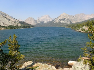
We descended over 1,600 feet in the next 1.5 miles to reach the shore of Grave Lake. This two hundred acre lake with a shoreline over two miles long would be the largest we would pass and the wind took advantage of this open space; as the waves crashing into the shore and spraying foam gave one the feeling of being at the beach instead of in the mountains. We caught cutthroat here and lake trout reportedly patrol the deeper depths that exist out beyond the shelf that extends in some places over 100 feet from the shoreline.The following morning we dropped our packs at the outlet and fished the stream and the lake. Once again the wind was in our face but we were rewarded with nice trout that would rise to dry flies as well as ambush deep damselyfly nymphs that were dredged through the channel creating the outlet.
A view back up Grave Lake from near the outlet
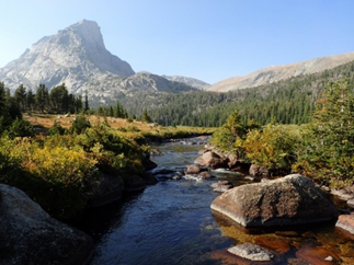
From the outlet we descended through the forest and within two miles arrived at the South Fork Little Wind River. This beautiful stream ranged from 10-20 feet wide and was full of trout. We dropped our packs and set up our rods, eager to fish moving water for a change. Speckled Wing Quills were in the air and the four of us spread out across a half mile stretch of the creek. Nobody was disappointed. Almost every cast was met with a strike from a brookie, cutthroat, or cutbow hybrid.
A typical stretch of water in the magical South Fork Little Wind River We shouldered our packs and hiked upstream into the headwaters, a tremendous basin called Ranger Park which contains over a dozen lakes holding trout. We climbed up to a shelf and found Valentine Lake tuck up against the steep walls of Windy Mountain. After setting up camp we fished the lake, catching numerous brook trout on dry flies as well as damselfly and streamer patterns. Fishing the lakes can be hit or miss. Sometimes the trout seem to be out and feeding and other times you can walk around the entire shore and never see a trout. Fortunately, this evening the trout were cooperating and we fished till dusk.
Crossing the creek in Ranger Park with Buffalo Head looming in the backgroundThe next day our destination was the headwaters of the North Fork Popo Agie River, another tributary to the Little Wind River. Our travels took us up and across the barren windswept slopes of Windy Mountain. The trail runs for over five miles above tree line at elevations exceeding 11,000 feet. A brief scramble to the top of nearby Cathedral Peak gave us an unrestricted 365 degree view from the 12,326 foot summit. The broad ridgetop of Windy Mountain is not a place you would want to be during fog or storms and we were fortunate to have crystal clear skies (and wind, of course). We arrived at Lizard Head Meadows and set up our camp at a point where the valley began to lose elevation as it dropped to the east. This gave us an opportunity to fish both a section with swift runs, plunge pools and pocket water as well as an upper section where the creek more closely resembled a swimming pool – crystal clear and just a few feet deep with hardly any measureable current. This turned out to be an excellent place to practice casting as a poor presentation or shadows from your line would set off a chain reaction of spooked fish.

The barren slopes of Windy Mountain. Not a tree to be found.Our campsite was located about two miles below the headwaters of the creek, which is formed in a stunning granite basin called the Cirque of the Towers. The cirque is an international rock climbing destination, with hundreds of technical climbing routes available. If there is a more beautiful place to catch trout then I have not found it. We were rewarded with incredible views as the sun set and dusk came upon us.

North Fork Popo Agie with Lizard Head in the background.
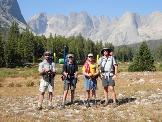
From left to right: Joe DeLisle, Neff Jenkins, David Ewing, and Derek Porter.
Sunset in the Cirque of the Towers
The following morning we broke camp and walked upstream in the cirque to the aptly named Lonesome Lake. The lake sits at 10,166 feet and is surrounded by a horseshoe shaped string of peaks towering over 2,000 feet above. After four days of wind we were finally rewarded with calm conditions. The location of the lake deep in the bottom of an ancient glacial valley sheltered us from the winds blowing high above. The calm conditions allowed us to see the trout cruising around the gin clear waters of lake. They were sipping emergers just below the surface. We spread out along the shoreline to find positions where we could make the long backcasts. There were boulders that could be waded out to as well as a shelf that could be waded out on so that you could reach the deeper water beyond. At first my offerings were met with mixed results but things improved immensely after switching to a 12 foot leader with size 20 midge adults with a pupa dropper. The longer leader with small flies definitely increased the chances of fooling the trout. For a few hours we all caught cutthroat after cutthroat. Never before have I fished a spot where every single trout was spotted before being cast to. Many of the trout were over 70 feet offshore which was feasible to reach when the wind was light and if you could find a spot for your back cast. The larger trout when hooked would take wide, sweeping runs as they desperately attempted to return to the depths of the lake. The combination of the scenery and the water conditions was surreal. We had plans to move on and fish other waters that day, being skeptical of how many trout we could catch in a lake at an elevation over 10,000 feet. On this afternoon however those plans were scrapped without even a discussion. There was no way were leaving this spot to fish anywhere else on this day. The fact that our car was over ten miles away and on the other side of the Continental Divide is the only reason we grudgingly broke down our rods, packed up and left. It turned out to be the perfect spot to make our final casts of the trip.
Sight fishing on Lonesome Lake
A view of the cirque and Lonesome Lake as we climb towards Jackass Pass
We crossed back over the Continental Divide at the curiously named Jackass Pass and began our descent towards Big Sandy Lake. Soon thereafter we were walking downstream along the Big Sandy River, reflecting on the trip as the sun set over the mountains to our left. A few miles later we set up our last camp in the dark, satisfied that we had made the most of our time in Wyoming’s Wind River Range Range.
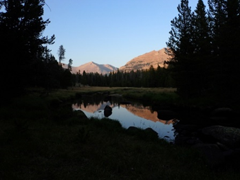
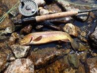
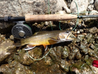
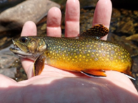
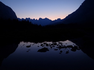
Reflections on the Big Sandy River near dusk Fish caught along the way: (next page)